Objectives
The first step of studying eelgrass is finding the eelgras! While this sounds simple, in most regions of the world currently no comprehensive maps exist for coastal marine ecosystems, so we often don’t know where eelgrass meadows are and how big and healthy they are. Finding eelgrass, getting access to it and then mapping it is therefore often the very first step of our work.
- Map
Map the extent of eelgrass meadows across Nova Scotia - Study
Understand the health of our eelgrass populations - Monitor
Map and track changes in meadow size and density - Explore
Explore historical extent of eelgrass around Nova Scotia
CERI is attempting to meet these goals by utilizing technology, community support, and fins in the water research! Knowing where eelgrass is now will help us understand where it may have been in the past, where it is thriving or declining, and where it may be in the future under a changing climate.
Eelgrass needs the following to be successful
- Sunlight to photosynthesise
- A sheltered environment with the correct soft substrate
- Suitable amount of nutrients
- Good water flow and quality
Not every part of the Nova Scotian coastline can provide all of the above factors, so we are attempting to map where suitable habitat is located. We are also trying to learn what works best for Nova Scotian eelgrass so it can thrive because every population is different.
Methodology
Threats to eelgrass success include, but are not exclusive to, human activity, coastal development, exposure to strong waves, invasive species, and climate change. In order to effectively restore eelgrass, we must keep all these potential challenges in mind. Since eelgrass is under the water, we need to extend our reach beyond what we can see from the shore. We do this in various ways:
Community Collaborations
Firsthand accounts and knowledge provided by long-term residents of the area are vital to our restoration efforts, saving us time and energy searching for eelgrass meadows.
Our research team works closely with the Confederacy of Mainland Mi’kmaq (CMM) and local Indigenous communities to gain a better insight into Mi’kmaq connections to eelgrass. The Mi’kmaq have been stewards of this land since time immemorial and have invaluable knowledge on eelgrass locations and health – both past and present. We learn from knowledge holders and community members and add these observations to our list! We also work closely with field technicians at CMM to increase our capacity and encourage different perspectives and approaches to our mapping work.
Citizen Science
We extensively use iNaturalist, an openly accessible database, that allows anyone to upload eelgrass observations (and all other species of flora and fauna). iNaturalist collects location data, so whenever someone in Nova Scotia uploads an image of eelgrass – we’ll know about it! iNaturalist allows anyone to participate in our mapping project, regardless of their scientific knowledge. Anyone can contribute to this work in our Eelgrass Mapping project in partnership with the Ecology Action Centre here. If you walk along shorelines, go snorkeling or diving, paddleboarding, swimming or surfing, and see eelgrass, please consider taking a photo and uploading it to iNaturalist. This is the basis of our work and we cannot overstate how valuable this information and your help is to us!
Eelgrass surveys
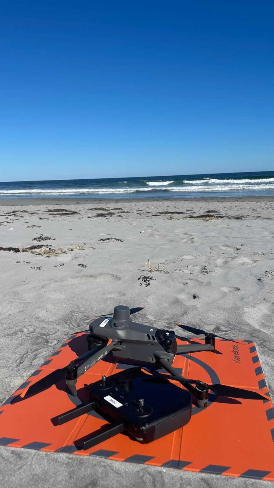
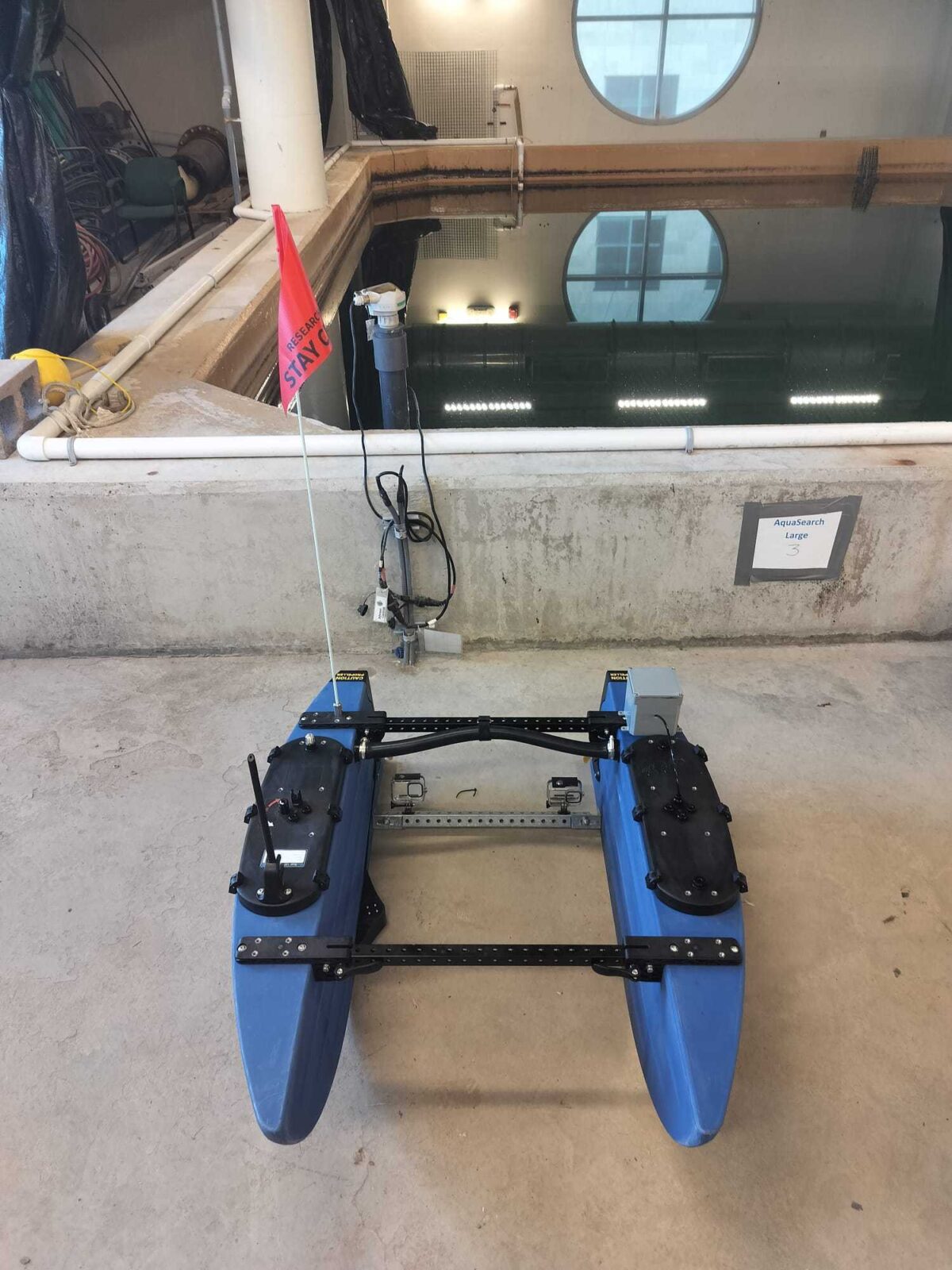
Once we have an idea of the suitability of a region, our team goes out into the field to search for eelgrass! We do so directly (snorkeling, shore walking) and indirectly (aerial drone and remotely operated surface vehicle). Our direct surveys with our faces in the water allow us to assess meadow health and density, which tell us how healthy and resilient a meadow is. However, one limitation with this type of survey is the time and energy it takes to snorkel through a meadow and record observations (not to mention the often chilly Nova Scotian waters). This is often further complicated by a lack of direct access to the water as the majority of Nova Scotia’s coastline is privately owned (if you want to learn more, Right of Way is a great, locally produced and award-winning podcast and also features our work). To circumvent these issues, we deploy our aerial drone and our small watercraft.
Approaches
We use our equipment in two ways:
- We fly our drone to find eelgrass and get a first impression of the meadow and to
- Deploy our blue boat to get a better understanding of the situation under water and the actual extent of the meadow.
Aerial Imagery
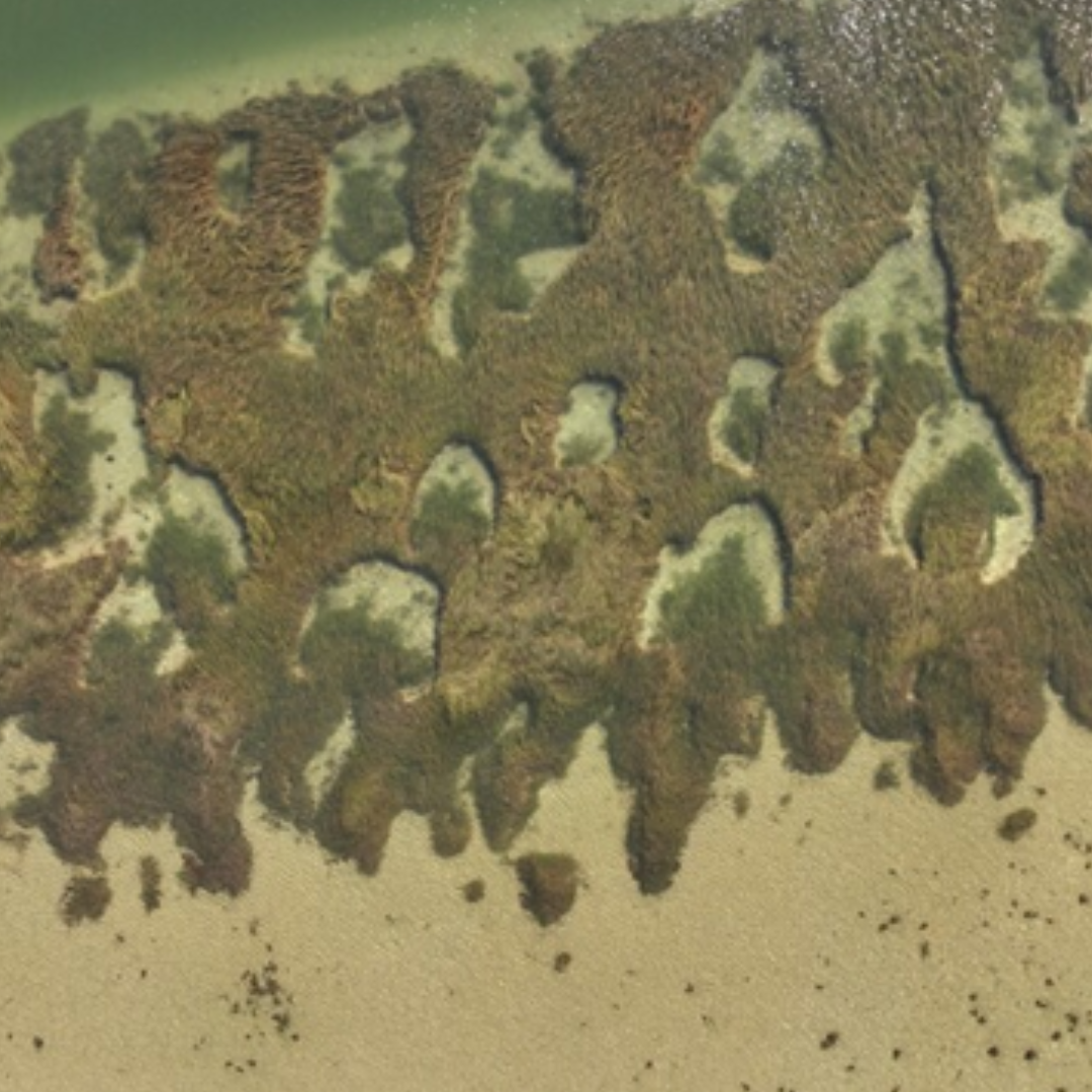
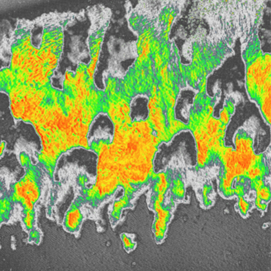
To monitor the size of an eelgrass meadow, we set a flight pattern for our drone and fly it over the meadow. The drone flies in pre-set transect lines, capturing imagery of the eelgrass using its onboard camera system. We also collect something called Multispectral imagery, which uses five camera sensors to collect images and video. One camera collects imagery like the type you would collect on your phone, while the other four collect colours at various wavelengths. We can use this imagery to highlight where eelgrass is or is not more distinctly. For more information on multispectral imagery, click here.
The second way we use the drone is to cover large distances and look for new-to-us eelgrass beds especially in areas where we cannot access most of the shoreline (about 87% of Nova Scotia’s coastline is privately owned, making access complicated to navigate. Read more about this here). We also collect data on where eelgrass is not present, refining our understanding of why eelgrass occurs in some places and not others.
Watercraft Imagery
While our drone collects imagery from the sky, it is often hard to detect eelgrass deeper than about 2-3 meters below the surface. That means we’re missing out on a significant area of eelgrass in our mapping efforts. This is where our surface watercraft, nicknamed the Blue Boat, comes in. Remotely operated on a similar transect to our aerial drone, our surface boat records underwater imagery, sonar and depth data. The collected video footage is segmented into frames, which we then use to create comprehensive orthomosaic maps of the meadows. The images also provide details on the state of the meadow as well as the density and patchiness of the eelgrass, complementing the aerial footage.
Outcomes
Our goal is to gain a comprehensive understanding of where eelgrass is currently growing and thriving, where it is not, and what changes are happening, whether they be natural or man-made. This knowledge will help us understand what contributes to a healthy eelgrass meadow, and what limits its chance of success. We will use this understanding to refine how we conserve and restore eelgrass in Nova Scotia, ideally protecting these ecosystems for generations to come.
Special Mentions
The mapping project is done in close collaboration with COVE and funding from Net Zero Atlantic. Thank you to CMM for the continual field and logistics support throughout this project. These collaborations are critical to the success of our research and for the future of eelgrass in Nova Scotia as they increase our capacity for monitoring and allow us to effectively monitor eelgrass on a larger scale.